La Perle du Maine
- Détails
|
Le Plan Cavalier : Sainte-Suzanne
Ce plan cavalier a été réalisé en 2023 par avec le concours de |
 Cliquez sur cette image pour cette autre vision Cliquez sur cette image pour cette autre vision |
- Détails
Venir à Sainte-Suzanne
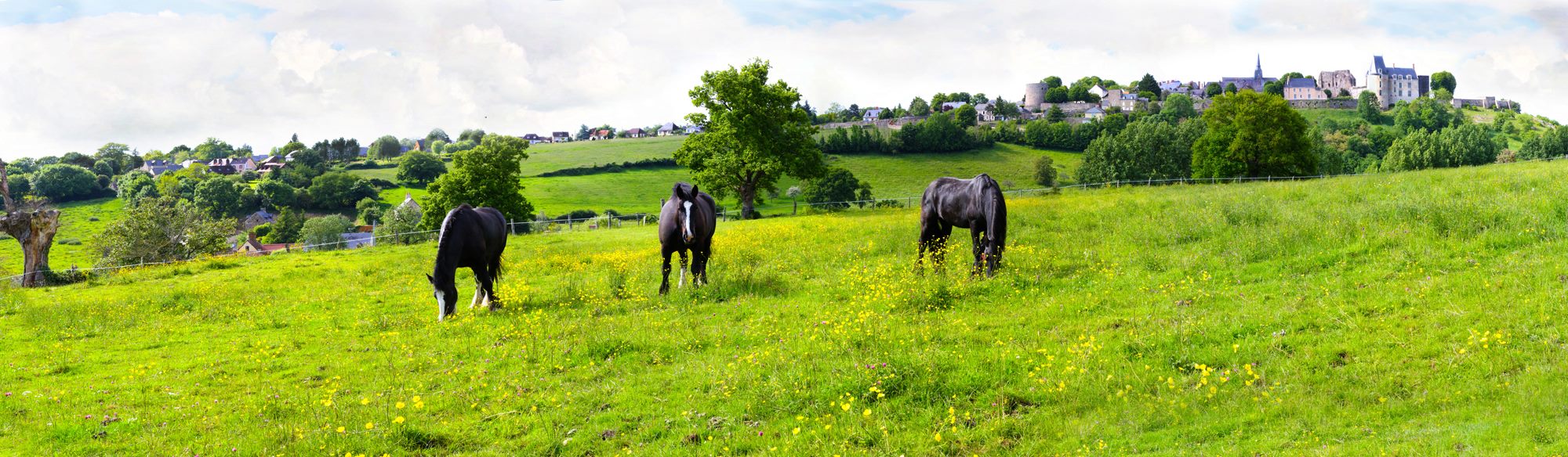
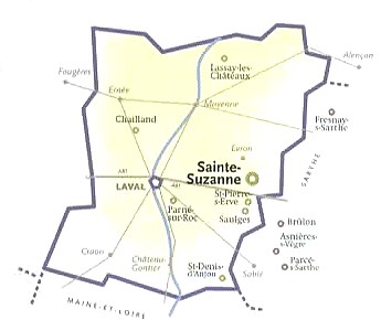
Ste-Suzanne, Perle du Maine, coeur des Coëvrons, se situe en Mayenne, au carrefour des Pays de la Loire, de la Bretagne et de la Normandie, mais également à proximité du bassin parisien, entre Le Mans et le Mont-Saint-Michel ! Cette localisation privilégiée et les réseaux de transports performants font de ce territoire une destination accessible et bien desservie.
Venez en voiture, en covoiturage, en bus, en train, en taxi !
En voiture
Situés sur l’axe autoroutier A81 Paris-Rennes et traversés par plusieurs routes importantes (RN 12, D 57), les Coëvrons sont facilement accessibles en voiture.
Le Mans – Ste-Suzanne 0h45 - 50 km
Angers – Ste-Suzanne 1h20 - 94 km
Rennes – Ste-Suzanne 1h20 - 110 km
Nantes – Ste-Suzanne 2h20 - 157 km
Ste-Suzanne - Le Mont saint-Michel 1h30 - 131 km
Paris – Ste-Suzanne 2h38 - 251 km >> A 2h38 de la Porte d'Orléans, la Perle du Maine !
Autoroute A11 jusqu'au Mans puis A81 Le Mans-Rennes, sorties : n°1 (Loué, Joué-en-Charnie, Sablé) en venant de Paris, ou n°2 (Vaiges) en venant de Rennes.
EN COVOITURAGE
En bus
La Mayenne est desservie par des lignes de cars longue distance (exemple : OUIBUS Paris-Bercy - Laval).
Elle est pourvue d’un système performant d’autobus permettant de couvrir une grande partie du territoire tout au long de l’année. Plusieurs lignes font étape dans les communes des Coëvrons. Contact : Gare routière de Laval (53000) 18 rue de Verdun Tél : 02 43 53 13 67
Ligne n° 3 : Laval – Sainte-Suzanne - 1h
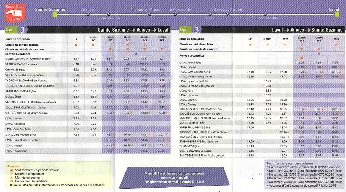
Le jeudi, un car vous emmène au marché d'Évron ! Ligne 130 : Sainte-Suzanne - Évron
Sainte-Suzanne - Place Ambroise de Loré 8h55 ; Rue de la Rivière 8h58 ; Chammes - Église 9h15
Évron : Dépose entre 9h55 et 10h00
En savoir plus sur le reséau de transport collectif Pégase
En savoir plus sur le reséau de transport à la demande Petit Pégase
En train

La gare SNCF la plus proche est celle d'Évron, à 7,5 km de Ste-Suzanne. Située sur la ligne Le Mans - Rennes, elle est desservie par les TER.
Laval – Évron = 20 minutes de TER ; Évron - Le Mans : 30 minutes de TER. Les gares de Laval et du Mans sont desservies par les TGV. Paris-Le Mans 55', Paris-Laval 1h28.
TAXIS : Lamy Sainte-Suzanne 02 43 01 47 68 Évron - Sainte-Suzanne = 7 minutes.
En avion
44340 Bouguenais 08 92 56 88 00 35136 Saint Jacques de la Lande 02 99 29 60 00
Visiter
Bienvenue à Sainte-Suzanne, Belle et Rebelle ! Visitez ses lieux emblématiques
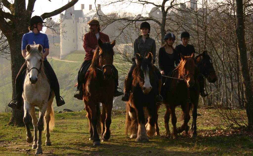
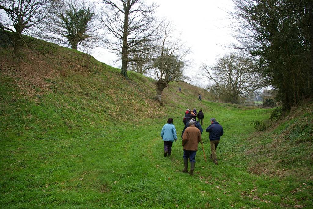
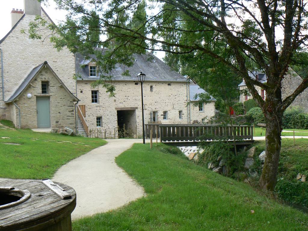
Visitez en vous promenant ! Promenez-vous en vous cultivant !

![]() Visites commentées de la Cité, Promenade des moulins
Visites commentées de la Cité, Promenade des moulins
Plongez ! piscine Jean-Taris de Sainte-Suzanne 
Photos : Roland Gaillard.
Dormir et séjourner à Sainte-Suzanne
Hôtel, Vvf-village, Chambre d'hôte, Gîte, Glamping, Hébergement insolite ... :
Explorez et choisissez votre hébergement en cliquant ici
Village de vacances VVF-village ***
| Camping-car Park |  |
Chambres d'hôtes :
(chambres d'hôtes, location de salle)
Gîtes, Meublés :
La Closerie de la Trottinière, Chammes **
Les Fiancés de Sainte-Suzanne ****
Le Grand-moulin ***
Habitats insolites :
Régalez-vous à Sainte-Suzanne !
Restaurant Beauséjour "Logis" **. Traiteur.
Restaurant Péché de gourmandise ;
Caf&Couette Cuisine traditionnelle ;
Buvette La Cabane, restauration rapide, traiteur ;
Brasserie La Suzannaise . Fabrication et dégustation de bières artisanales et limonades. Boutique, bar de dégustation.
Boulangerie-Pâtisserie Ophélie LESNÉ & Jordan DROUIN
Confiserie Les sucreries de Jane
Gastronomie aux alentours
![]() Hôtel du Commerce, à Vaiges 12 km
Hôtel du Commerce, à Vaiges 12 km .png)
.jpg)
![]()
.png)
.png)


Au relais du Gué de Selle, à Mézangers 13 km
- Détails
Dormir et séjourner à Sainte-Suzanne
Hôtel, Vvf-village, Chambre d'hôte, Gîte, Glamping, Hébergement insolite ... : Explorez et choisissez votre hébergement en cliquant ici
Village de vacances VVF-village ***
Aire aménagée Camping-car Park
Chambres d'hôtes :
Gîtes, Meublés :
La Closerie de la Trottinière, Chammes **
Les Fiancés de Sainte-Suzanne ****
Le Grand-moulin ***
- Détails
Régalez-vous à Sainte-Suzanne !
Restaurant Beauséjour "Logis" **. Traiteur. 

Restaurant Péché de gourmandise ; Caf&Couette Cuisine traditionnelle ; Buvette La Cabane, restauration rapide, traiteur ; Brasserie La Suzannaise . Fabrication et dégustation de bières artisanales et limonades. Boutique, bar de dégustation.
Boulangerie-Pâtisserie Ophélie & Jordan
Confiserie Les sucreries de Jane

Gastronomie
![]() Hôtel du Commerce, à Vaiges 12 km
Hôtel du Commerce, à Vaiges 12 km ![]()

Au relais du Gué de Selle, à Mézangers 13 km 

![]()
![]()
![]()
.jpg)
![]()
![]() La Croix verte, à Neau 12 km Traiteur.
La Croix verte, à Neau 12 km Traiteur.
L'Éveil des sens, à Mayenne 30 km
- Détails
Sainte-Suzanne
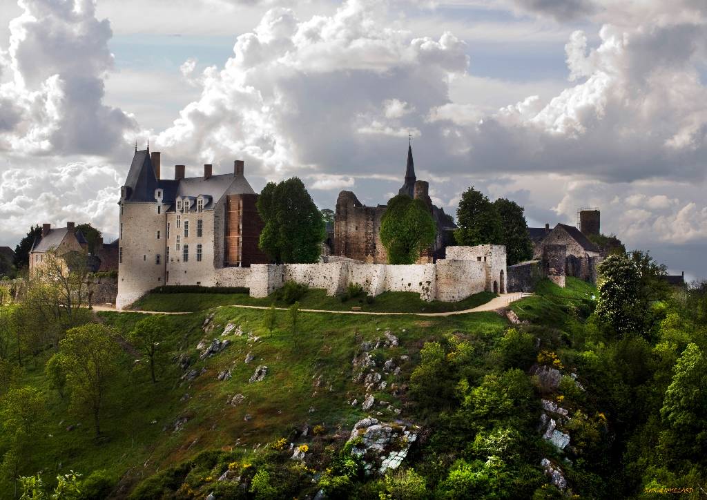
Located between Laval and Le Mans, the fortified town of Sainte-Suzanne was once referred to as « The Key of the Maine » because of its strategic location.
Classified today as one of the Most Beautiful Villages in France and one of the Small towns of character in the Pays de la Loire.
There is also a Discovery trail of the local heritage
History
Sainte-Suzanne has a long history dating from prehistoric times. Near the town are two dolmens or cromlechs dating from the mid 5th century BC and archaeological research has uncovered evidence of occupation of the site by the Celts between the 9th and 5th centuries BC and subsequently by the Gauls.
By the early Middle Ages it had grown to some importance as a stronghold occupying a strategic position in the County of Maine (comprising roughly the modern departements of Sarthe and Mayenne). The Counts of Maine were based in Le Mans, but among the seats of the Viscounts of Maine was Sainte-Suzanne.
The castle keep dates from the early 11th century and first figures in recorded history when it was besieged by William the Conqueror in 1083. Although the siege was maintained for some three years William never captured Sainte-Suzanne.
In 1425, during the Hundred Years’ War the town was captured by the English who attacked it with a new weapon ─ artillery. Sainte-Suzanne surrendered and was under English occupation for fourteen years until a soldier in the garrison, John Ferremen, an Englishman who had married « a fine woman from the Maine » gave access to French troops led by Jean de Bueil a knight who had fought alongside Joan of Arc.
By the early 17th century, the Barony of Sainte-Suzanne had passed to Queen Margot, the wife of king Henri IV, who sold it to Guillaume Fouquet de la Varenne, a close friend of the king, who became France’s first Postmaster General. He it was who set about building a « modern » château ( Logis ) along the southern ramparts of the mediaeval castle.
In the following centuries the town thrived. The two kilometre stretch of the River Erve below the town provided power for watermills and during 18th and 19th centuries some 17 of these were built, among them flour mills, paper mills, fulling mills and tanneries. The wealth of the bourgeoisie of Sainte-Suzanne is reflected in the rebuilding of the manors and houses which took place in the upper town during the 18th century.
A Walk around Sainte-Suzanne
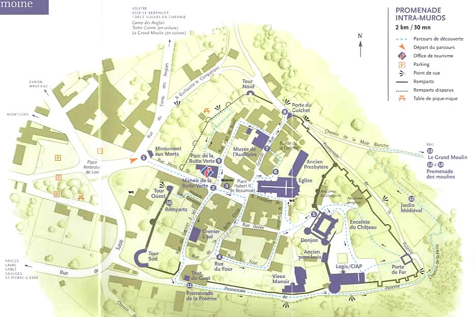
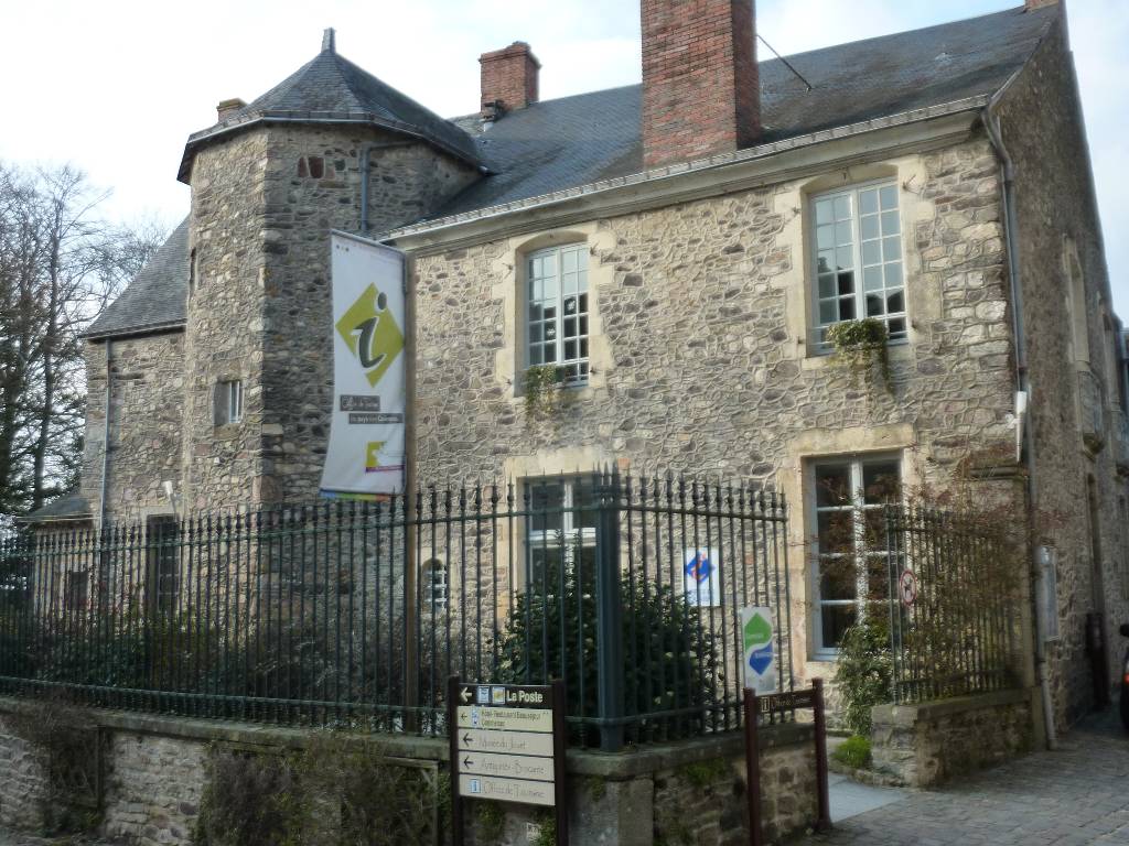
From the Place de Loré take the rue Henri IV, passing on the left the War Memorial ❶ on either side of which stand two French field guns. There were captured by the Germans 10 1940 and were used to shell Sainte-Suzanne during the battle to liberate the town in early August 1944. Halfway up the street a line of cobbles in the road indicates where a section of the town ramparts were demolished when the street was created in the 19th century. On the left at the top of the street is the Ste-Suzanne and Coëvrons Tourist Office ❷ and beyond that the Mairie ❸ (old Town Hall).
In the square in front of the Mairie lines of cobbles indicate the site of the original Halles where for centuries markets were held and justice was dispensed until they made way for the contruction of the new Mairie in 1884. Turn right into the rue de la Belle Étoile and descend to the rue du Four (second on the left). Follow the rue du Four ❹ and in front you will see the towers of the old Manor and the Castle.
The rue du Four leads to the square in front of the castle where you will see the rectangular keep dating from the early 11th century and the encircling walls and towers which date from the 12th and 13th centuries. On the right in the dry moat is the original entry to the medieval castle ❺ which was once protected by a drawbridge and portcullis.
Entry to the castle grounds and the keep is free. In the courtyard you can also admire the renaissance château built by Guillaume Fouquet de la Varenne in the early years of the 17th century. This building now houses the Centre for Interpretation of Architecture and Heritage for the Department of Mayenne (CIAP).
On leaving the castle follow the rue Fouquet de la Varenne back to the main square where stands the church. This building dates from 1884 and stands on the site of two earlier church buildings, one dating from the Middle Ages and the second from the 16th century. The carved portal of 1555 church framing the door of the present church is the only remaining vestige of the earlier buildings.
The Church ❻ houses a number of interesting statues dating from the 14th to the 18th century, most notably a paricularly fine statuette of John the Baptist and, in the choir, a statue of sainte Suzanne, patron saint of the fiancés (engaged).
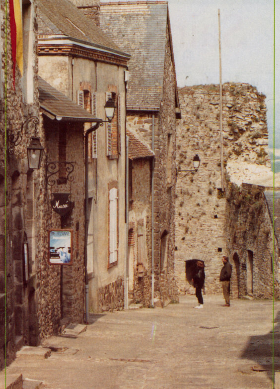
Descending the Grande rue (High Street !) you will find on your left the Musée de l’Auditoire ❼, the museum of local history (9 rooms) which contains an interesting collection of artefacts relating to the town, including the oldest plate armour ever found in France. Opposite the museum is a house with an exceptionally large window. This is the Carterie, a 17th and 18th century factory producing playing cards manufactured from paper produced by the local mills. The large window gave light to the draughtsmen and printers who were producing the cards.
At the bottom of the Grande rue is the former entrance to the fortified town. In the Middle Ages this was protected by towers and drawbridge, and later by a Ravelin, a stone-built gun platform.
On the right is the so-called Porte du Guichet ❽, a postern gate, a small well defended gate which permitted discreet entrances and exits.
Returning up the Grande-rue, take the first street on the right, rue Jean de Bueil, which leads to the large gateway behind the Mairie, opening on the Butte Verte and its manor house ❾ (Current town hall) dating from the 16th century with later alterations. The park was once much smaller, but a one-time owner of the manor decided to enlarge it by demolishing of the town ramparts ❿. The original line of the rampart and its towers are marked by cobbles. From the small garden to the right of the courtyard there is a fine view of the Coëvrons hills.
On leaving the courtyard turn right and cross the rue Henri IV into the rue du Grenier à sel. Immediately on the right an alley, the impasse John Ferremen gives access to a stone stairway to the top of the West Tower with views over the landscape to the north and the west. Carry on down the hill and on the left is the Grenier à sel itself. This was until the Revolution of 1789 the building where salt was stored. At that time salt was a precious commodity and was subject to a hefty tax, the gabelle.
At the bottom of the street there was a second entrance to the town, but this was later walled up to improve security before being reopened in the 18th century. To the left is a tall square building which is a former watchtower.
Turning left you enter the Promenade de la Poterne ⓫, a walkway alongside the ramparts with impressive views of the valley of the River Erve and the former mills which provided the wealth of the town until the 19th century, the Tertre-Ganne (the high ground of the far side of the river) as well as the surrounding countryside. Half way along the walk the ramparts make a sharp turn and there you will find the Porte de la Herse or the Porte de Fer (the Portcullis Gate or the Iron Gate). This was the rear entrance to the castle yard.
Continuing the walk you will return to the Porte du Guichet and the Grande-rue.
What to see in the vicinity
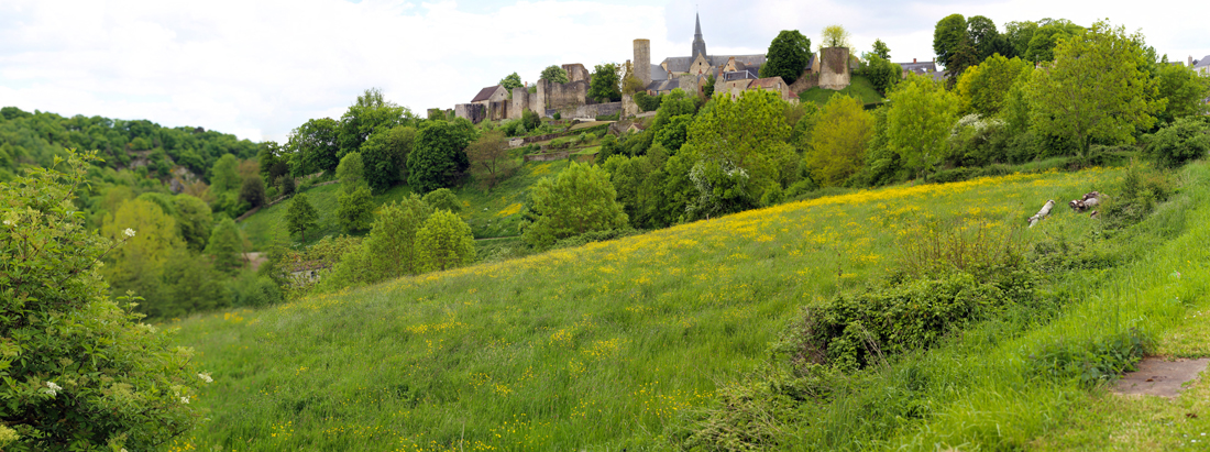
Tertre-Ganne
From this promontory to the south of the town there is a stunning panorama of Sainte-Suzanne. It can be reached by car, taking the direction of Voutré, turning right just beyond the pond at the foot of the hill. Follow this road to the summit where there is a car park. An easy 100 metre walk brings you to a picnic site with superb views of the town.
Camp de Beugy
Less than a kilometre from Sainte-Suzanne in the direction of Assé-le-Bérenger, on the left of the road lies the Camp de Beugy, also known as the Camp des Anglais. This impressive earthwork fortification believed to have been used as a base by the troops of William the Conqueror in 1083-1086 when they laid siege to Sainte-Suzanne.
- Tourist information and documentation can be obtained at the Tourist Office as well as at the Château, the Musée de l'Auditoire, the Grand Moulin and at some of the shops etc in town.
- Guided tours in English take place on the second Tuesday of every from May to October. Meeting place is the Tourist Office at 4pm and the tour lasts about 90 minutes. Price is 3.50 euros.
- Visits at other times can be arranged for groups of 10 or more through the Amis de Ste-Suzanne.
amis.saintesuzanne @ gmail.com https://www.amissaintesuzanne.fr/

Ste-Suzanne – Les Coëvrons Tourist Office
1 rue Jean de Bueil
F 53270 SAINTE-SUZANNE-ET-CHAMMES
Ph +33 (0)2 43 01 43 60
https://www.coevrons-tourisme.com/en
www.ste-suzanne.fr
Musée de l’Auditoire (3000 years history)
7 grande rue
F 53270 SAINTE-SUZANNE-ET-CHAMMES
Ph +33 (0)2 43 01 42 65
https://museeauditoire.jimdo.com/
Grand-moulin (paper mill)
Rue aux chevaux
F 53270 SAINTE-SUZANNE-ET-CHAMMES
Ph +33 (0)6 16 43 40 46
https://www.moulin-papier.com/
Château of Ste-Suzanne
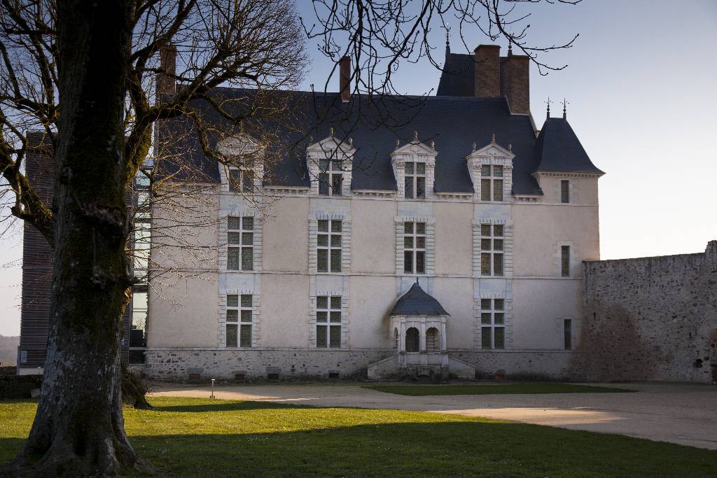
(CIAP : Center of interpretation of architecture and heritage)
1 rue Fouquet de la Varenne
F 53270 SAINTE-SUZANNE-ET-CHAMMES
Ph +33 (0)2 43 58 13 00
https://www.chateaudesaintesuzanne.fr
Page 1 sur 2